|
 |
The Village of Center Line,
Michigan
1932 Partial Maps, Facts and Photos
The maps at the bottom of this page cover about one-fourth of the village and they were created in July of 1932 for fire insurance rating purposes. Included are a small scale map of all the streets in the village, plus a larger scale map showing the lots and houses in the area bounded by Van Dyke Ave., Warren Blvd., Sylvan Ave. and Wilson (Busch) Ave. Similar maps from 1927 can be viewed here .
|
|

Members of the Center Line Volunteer Fire
Department, circa 1931, shown with their 1926 American La France
Pumper.
Seated in cab (left to right): Elmer Fleschig, Clem Grobbel.
Back row (left to right): Joe Wiegand, Norb Rinke, Tony Vohs, Ed
Grobbel, Ed (Sach) Schoenherr, George Rinke, Paul Elwart, Nels
Giff, Bert Grobbel.
Front row (left to right): Leo Grobbel, Nels Zott, Dave Smith,
George Theut (Chief), Jake Schnider, Mark Kunath, Harold Stilwell,
Leo Schnoblen.
The histories of Center Line and the Grobbel family are very much intertwined. Here are some facts and recollections:
prior to 1925, Center Line was an unincorporated village of about 1,300 residents that was a part of Warren Township.
on 09 Nov 1925, voters accepted the work of the Charter Commission and Center Line became an incorporated village (it would remain a village until it became a city in 1936)
the village council purchased an American LaFrance Fire Engine in March of 1926 (which was housed in Fire Chief George Theut's garage at 152 Engleman Ave.) and also put into motion a plan to create a municipal water system for drinking and fire protection
the new water facilities included two 122 foot deep wells and a 90 ft. tall, 100,000 gallon water tower, all located on Ten Mile Rd. between Wyland and Landau Avenues. By 1932, the distribution system included 15 miles of 6" and 8" water pipe and 75 fire hydrants. Average daily water consumption was 85,000 gallons, delivered at an average of 55 PSI.
in September of 1927, voters approved a $30,000 bond issue for construction of a municipal building on Ten Mile Road between Wyland and Landau Avenues, just west of Van Dyke Ave., and upon it's completion, the fire department was relocated there. In 1932, the Center Line Fire Department had two chiefs, fully paid, one on each 24 hour shift, plus 16 volunteer fireman (including Clement, Leo, Edward, and Bert Grobbel) who were paid by each call.
the village population in 1932 was 2,604 individuals (down from 3,333 in 1927)
by 1932, Van Dyke, Ten Mile, Eleven Mile, Warren Blvd. and Sherwood were all paved with concrete.
After their marriage in October of 1921, Clement & Marcella Grobbel rented and lived in the house at 127 Central Ave. (also identified as number 215 on the map below, which was an arbitrary number used by the mapmaker; today the street address is 8129 Central Ave.). This was on Lot 114 of the "H. Renshaw's Center Line Subdivision" and it was the ninth house from the northwest corner of Evelyn and Central Avenues.
Other families who lived on the north side of Central Ave. included: Tharret (Lot 127), Lietz (Lot 124), Tony Schimmel (Lot 121), Hall (Lot 120), Frank Phaneuf (Lot 117), Rudy Wilke (Lot 115) and Ed and Roxanna Carney (Lot 113). Ed Carney was elected to the first village commission on 09 Nov 1925. Roxanna Carney and Clement Grobbel would marry in 1940 after the death of both of their spouses.
|
|
by 1931, Clem's business had gone
bankrupt (he was then a Center Line Police Officer in
addition to being a volunteer fire fighter; on 31 March
1936, Clem would be appointed as the first Police Chief
for the newly-organized
City of Center Line). The buildings at the rear of Lots
133 & 134 on Dale Ave. were now identified as "vacant"
on the 1932 map. The structure at the rear of Lot 134 was
later torn down and the materials used in the
construction of the house Clem built on Lot 133 beginning
around 1935 (today that house's address is 8070 Dale Ave.).
The garage-type structure at the rear of Lot 133 still
stands today.
on the 1932 map, the three houses shown on the south side of Dale Ave. west of Evelyn belonged to Bernard "Ben" & Catherine Grobbel (Lot 141, 8134 Dale Ave.), Frank Wiegand (Lot 143, 8150 Dale Ave.) and Anthony & Mary Grobbel (Lot 145, 8166 Dale Ave.). Anthony Grobbel built this house in 1926 and moved into it in July of that year after his farmhouse at 11 Mile Rd. and Mound burned on May 16, 1926. Anthony kept his Model T in the garage at the rear of Lot 140 and when he would back it out into the alley, he would often hit the fence at the rear of his son Clem's yard and cause it to lean over. The garage-like structure at the rear of Lot 142 housed the well and pump that supplied drinking water to Renshaw's Subdivision prior to the installation of the municipal water system. Frank Wiegand was a well driller and the garage he used to store his equipment on Lot 143 was originally the old "Grobbel & Vohs" Plumbers and Electricians building that used to stand on the east side of Van Dyke, south of Ritter Ave.
Along the east side of Van Dyke Ave., beginning just south of the St. Clement Priest House, were the following businesses:
25310 Van Dyke - Dick Teich's Bakery (Lot 3); later Renaud's Shoe Repair
25306 Van Dyke - U.S. Post Office (Lot 3) (from 1928 until 1939); later a Chocolate Candy Shop, then Liberty Cleaners
25302 Van Dyke - Dismore's Meat Market (Lot 3)
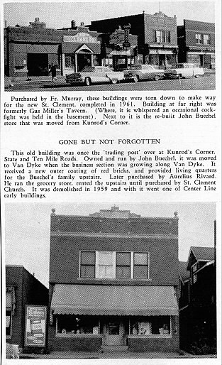
25258 Van Dyke - John Buechel's Grocery Store (with apartments above) (Lot 3); later Aurelius "Real" Rivard's Grocery Store
25250-2 Van Dyke - Gus Miller's Bar (with apartments above) (Lot 4)
25226 Van Dyke - Heck's Barber Shop (Lot 1) (the ice house used to be located nearby to the rear of this building)
25222 Van Dyke - Texaco Gasoline Filling Station (Lots 2 & 3 at the corner of Ritter Ave.)
25160 Van Dyke - Shoe repair shop (Lot 2)
vacant lots - formerly the site of "Grobbel & Vohs" Plumbers and Electricians (much later this was the site of the second Wolf Hardware Store)
25134-46 Van Dyke - Ben Wolf Building; built in 1921 at the northeast corner of Warren Blvd., it included Ben's hardware store, the Edison Office (later Homer Hazelton's Drug Store) and his family's upstairs living quarters
the first house on the north side of Ritter Ave. (Lot 6) belonged to the Henry & Esther (Hayes) Peters family, while the first house on the south side (Lot 3) belonged to the Louis & Mary (Rotarius) Kaltz family. Clem Grobbel's wife, Marcella Peters, was the daughter of Henry & Esther Peters.
the smaller scale street map of the entire village indicates that:
Mackersie Rd. was shown just a half-block to the north of, and paralleling, Helen Ave., between Lawrence and Van Dyke Avenues, however, if it was ever constructed, it no longer exists
some of the street names shown on the map have changed over time: St. Clement Ave. became Stephens Rd., Herbert became Lorraine Ave., Church Road became Engleman Ave. (east of Van Dyke), Meyer became Arsenal Ave., Wilson became Busch Ave., Lincoln became Menge Ave. and Washington became Potomac Ave.
a subdivision plat that was never constructed is shown in the area bounded by Sherwood, St. Clement (Stephens), Lawrence and Ten Mile - this area remained undeveloped until the 1970's. This undeveloped subdivision would have extended all of the existing named streets from the east while bisecting them with a north-south street named "Groesbeck". In 1932, Groesbeck was also the name of the first street east of Sherwood that ran from Eight Mile Road north to Lozier Ave. and which is now called Memphis Ave.
the south side of Dale Ave.between Van Dyke and Evelyn would later be home (or almost home) to several other Grobbel families. Shortly after he got married in 1949, Vincent Grobbel (Clem Grobbel's son) bought Lot 135 with intentions to build on it, however he sold it about a year later when he bought a house at 24836 Godin Ave. in Center Line. Thomas Grobbel (Ben Grobbel's son and a City Councilman from 1957 to 1962), owned the house that was later built on Lots 138-9 (8112 Dale Ave.). In the mid 1960's, Mark A. Grobbel (Clem Grobbel's son and a Center Line Police Officer who was appointed Center Line Public Safety Commissioner in 1969) bought a house on the north side of Harding near Van Dyke and had it moved onto Lot 140 (between Tom and Ben Grobbel's houses and the site of the old garage where Mark's grandfather used to keep his Model T). In 1973, the Frank Wiegand house (Lot 143, 8150 Dale Ave.) and the vacant lot adjacent to it (Lot 144) were placed on the real estate market and Mike Grobbel (Vince Grobbel's son) considered purchasing it, but decided against it. At that time, Lot 143 still had an underground gasoline tank and the hand-powered, gravity feed gasoline pump with a clear glass reservoir. After the deaths of Anthony and Mary Grobbel in 1942, their house on Lot 145 (8166 Dale Ave.) was passed on to their children, and it was eventually the home of their bachelor sons, Edward and Leo Grobbel. Leo (aka "Jumbo") had his living quarters in the basement and used the garage to store the tools and supplies for his plumbing business until he died in 1962. For 50 years, Edward was a recognized leader in many charitable societies and clubs in Center Line. Their house was eventually sold after Edward died in 1982.

(click to enlarge)

(click to enlarge)

(click to enlarge)
Previous:
The Village of Center Line, Michigan - 1927 Partial Maps,
Facts and Photos
Return:
Center Line, MI
Historical Information - Home Page
For more information:
History of the City of
Center Line - Center Line Municipal Web Site