Through the Years - a
Photographic History of Center Line, Michigan
A block-by-block
photographic tour of Center Line as it appeared in days gone by.
PART 1 | PART 2
Unless noted otherwise, all
photos are from the collection of
Captions and text by Mike
Grobbel
Click on any thumbnail photo below
to view a larger sized image of it, which will open in a new
window. In order to view most of the larger images at their full
size, you will also have to position your cursor on the image and
then click on the "Enlarge" button in the lower right
corner of the image. Close the new window to return to this page.
Click here to view a 2004 street map of Center Line, which will
open in a new window.
Center Line Municipal Garage, northwest
corner of Sherwood and 10 Mile Rd. (ca. 1970s)
Busch School, north side of 10 Mile,
between Sherwood and Liberal Ave
Looking nowthwest from the corner of Landau and 10 Mile (mid
1960's)
Kroger Grocery Store, located on 10 Mile Rd. across from
the old City Hall (mid 1960s)
Center Line City Hall as viewed from the northwest corner
of 10 Mile and Van Dyke (late 1950's). The building to
the left was Ben Jackson's old office building which used
to stand on the NE corner of 10 and Van Dyke.
Aerial view looking southeast showing the vicinity of 10
Mile between Lawrence and Van Dyke (early 1970s)
Busch High School Band
Van Dyke, south of 10 Mile
Road
Van Dyke looking north towards
10 Mile Rd. from Edward Ave. (ca. 1960)
Van Dyke looking north towards
10 Mile Rd. from Edward Ave. (June 2006)
Van Dyke between 10 Mile Road
and Warren Boulevard
Children pose in a wagon on the farm at the northeast
corner of 10 Mile Rd. and Van Dyke (ca. 1920s)
Family members outside the farmhouse at the northeast
corner of 10 Mile Rd. and Van Dyke; note the well hand
pump and also the streetcar tracks which ran down the
east side of Van Dyke. (ca. 1920s)
The "Midwest Unclaimed Freight" store at the
northeast corner of 10 Mile Rd. and Van Dyke (ca. late
1960s). The "Tip Top Market" formerly operated
in this building. Prior to that, Ben Jackson moved his
office building kitty-corner across the street to make
way for Louis Cohen, who operated a market here that
started out as a fruit and vegetable shed.
Daytime and nighttime views of Homer Hazelton's
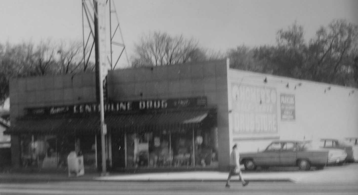
Self-Serve "Center Line Drugs" (ca. 1960s).
Homer's drugstore business originally started out in the Wolf
building at the NE corner of Warren Blvd. and Van Dyke.
Van Dyke between 10 Mile Road
and Qualmann
Grissom's used car lot at the northwest corner of 10 Mile
and Van Dyke (ca. 1950)
Grissom's new car Studebaker dealership at the corner of
Qualmann Ave. (ca. 1950)
Newly constructed shopping center at the northwest corner
of 10 Mile and Van Dyke (early 1970s)
Van Dyke between Qualmann and
Weingartz
The William LeRoy livery and
blacksmith shop as it appeared circa 1911 (near right)
and 1920 (far right). Note the electric street car tracks
that ran along the east side of Van Dyke. The house at the far left in the near right photo was built in 1910 on the northwest corner of Qualmann Ave. and sometime in the late 1920's it was moved to its present location on Weingartz Avenue, immediately west of the Library.
Johnny's
Recreation pool hall (far left photo) and the entire
block is shown in the near left photo, which was taken in
the spring of 1962. Jerry Schoenherr's Center Bar was at
25117 Van Dyke and had been the location of the Center
Line Drug Store back in the early 1920's. The Drug Store
was the first location of the Center Line Post Office
from its establishment in 1921 until 1928 when it moved
to 25306 Van Dyke, just south of old St. Clement Church.
Vincent Grobbel is
wearing his costume and standing in the front passenger
seat as his clown car entertains parade-goers along Van
Dyke (mid 1950s).
The 1945 photo at far left shows the
Robinson Lumber Co. building and its next door neighbor,
the Liberty Theater (photo courtesy of the Water Winter Wonderland website). The Liberty Theater was built in 1927 and
continued operation into the 1950's. It later housed
Skelly's Roller Skating Rink. The photo at near left
shows these buildings as they appeared in the mid to late
1960's. The C.F. Gibbs Lumber Co. had taken over Robinson's
building and the Skating Rink was now the home of Grissom's
Collision shop. The William LeRoy blacksmith shop once
stood at about the same spot as the lumberyard, which was
at 25135 Van Dyke.
Van Dyke between Weingartz
and Wiegand
Michael
Weingartz and family are shown on their 30 acre homestead farm, which was located on Van Dyke, across from St. Clement Church. This photo was taken around 1895 or 1896 and the couple on the left is Michael Weingartz and his wife Gertrude (Miller) Weingartz. The woman on the far right is Barbara (Schmitt or Smith) Weingartz (wife of their son, Joseph Weingartz). The child holding Gertrude's hand is Barbara and Joseph's son, Michael Weingartz (b. 1892) and the other child is their son, Christopher Weingartz (b. 1894). Christopher's son is the Roman Catholic priest, Fr. Francis Weingartz. (photo identifications provided by Elizabeth (Hessell) Malburg, granddaughter of Joseph and Barbara Weingartz).
This photo at right
shows the three buildings on this block as they appeared
in the spring of 1959. The southern-most building at
25211-25215 Van Dyke was built prior to 1914 and in the
1930s it was owned by the Fiore family. Prior to about
1938, the top floor was used as a dance hall. It was then
converted into three apartments, one large one across the
back and two smaller ones at the front. From 1939 until
1949, the US Post office was located on the first floor
in the southern store-front. The city library was the
next tenant and when it was moved to the nearby
Recreation Building, it was replaced by the cleaners
shown in the photo. The northern store front was a
restaurant for most of these years. The next building to
the north was the office of Dr. James Bryce, M.D. The
large building north of the doctor's office at 25239 Van
Dyke was the "Automotive Shop" at the time this
photo was taken. Previously it had been the Kroger
grocery store and before that it had housed Wiegand's
Garage.
As part of Center Line's urban renewal
project, the eastern-most 300 feet of Weingartz and
Wiegand Avenues were vacated and a new street was built
that took their traffic to the north, ending at Engleman
Ave. This "vest-pocket park" (near right) was
built on part of the vacated Weingartz Ave. right of way
and both the new street and park were named after Paul G.
Hazen. As the June 2006 photo on the far right shows, the
park has been renovated over the intervening 35+ years
since the first photo was taken.
Paul Gordon Hazen was
the son of Adelbert G. Hazen (Center Line Mayor, 1954-1960)
and his wife, the former Leona Borsekowski. Paul was born
on Sept. 7, 1944 and in 1965 he was drafted into the U.S.
Army. On Dec. 4, 1965, SP4 Paul Hazen began a tour of
duty in South Vietnam that ended on Sept. 23, 1966 when
he died of multiple fragmentation wounds suffered during
hostile action. He was the first Center Line soldier to
die in the Vietnam war.
According to this source, three
other Center Line residents also died in Vietnam:
The photo post card at left was taken
circa 1914 looking north from about the middle of this
block.
The photo at right was
taken from about the same location sometime during the
1930s.
The post card photo at near right was
taken circa 1914 looking south from a point just north of
the intersection with present-day Ritter Ave. (from the
collection of Mike Grobbel)
The
photo at far right was taken in 1922 from about the spot
where the horse and buggy stood in the photo taken eight
years earlier.
Examining the full size
version of the circa 1914 photo reveals that further down
on the left (east) side of Van Dyke (then known as Main
St.) is a Detroit United Railway streetcar that is parked in the turn-around loop at the
end of the line. The interurban streetcar line to Detroit
began just south of present-day Warren Blvd. and the
utility poles that supported the electrical cables that
supplied the streetcars are also visible alongside the
tracks. The farmhouse and buildings behind and to the
left of the streetcar were located at the northeast
corner of Ten Mile Road and Van Dyke. The first building
down the right (west) side of Van Dyke from the camera
would later house the Post Office from about 1939 until
1949 (this building also housed at various times the city
library, a clothes cleaners and a restaurant). The second
building down the right was William LeRoy's livery and
blacksmith shop. In the late 1920's Robinson's Lumber Co.
(later Gibbs) and the Liberty movie theater would be
built on that site.
The intersection of Van Dyke and
Ritter Avenues as it appeared in the 1960s. The photo at
far left was taken in 1961 when regular gas was only 20.9
cents per gallon and premium gas could be had for 25.9
cents per gallon!
The building on the southeast corner of Ritter Ave was originally
a gas station which was owned at one time by Johnny Cavacece, but
by the mid-1960's it had become a used car lot. Just south of
that was a shoe repair shop, followed by Wolf's Hardware store at
25152 Van Dyke. The adjacent dark brick building was known as the
"Ben Wolf Block" building. Bernard "Ben" Wolf
built this building in 1921 and moved his family into the
upstairs apartment. The lower level storefronts were occupied
over the years by Ben's first hardware store and other businesses
like Detroit Edison, Brickley Dairy, Homer's Drugs and a real
estate office.
After the urban renewal claimed this block, Ben Wolf's heirs
built this new "Wolf's Hardware" on the
site of their previous two stores. Today this building houses a
Harley-Davidson motorcycle dealership.
Visit these pages for more information about
a) Wesley
Arnold, who collected these old photos and has Mike
Grobbel, who supplied the captions for
these old photos and created these web pages
c) the History of the City of Center Line
at the Center Line municipal web site