Center Line & Warren Twp. Street Maps from 1927, 1932 and 1941
These maps were prepared by the Sanborn Map Company for fire insurance rating purposes. In addition to fire hydrants and water mains, they also show the location, shape and type of construction for all structures, plus their street addresses.
These maps are saved in the PDF file format which
allows you to zoom in and out and print at different scales,
however you must have the Adobe Acrobat Reader software installed
on your computer.
To download a free version of Acrobat Reader, go to http://www.adobe.com/acrobat
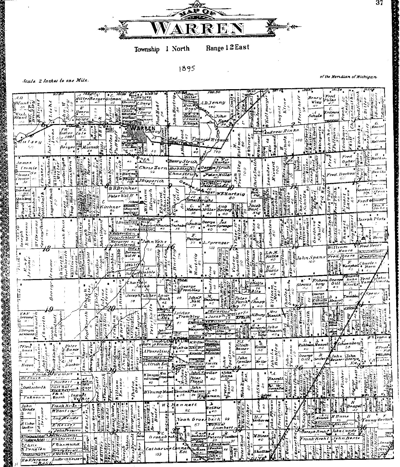
At the very bottom of this page are links to Warren Township Plat Maps from 1875 and 1895, plus Macomb County maps from those same years.
Use your browser's "BACK" button to return to this page after viewing a map.
1927 Maps
Overview map, plus Central, Harding, Engleman
streets and east side of Van Dyke:
sanborn_1927_1.pdf
Helen, Dale, Voerner, Gronow, Engleman streets
and west side of Van Dyke:
sanborn_1927_2.pdf
Engleman, Wiegand, Weingartz, Qualmann streets
and west side of Van Dyke:
sanborn_1927_3.pdf
Engleman, Ritter, Warren Blvd. and east side of
Van Dyke:
sanborn_1927_4.pdf
1932 Maps
Helen, Dale, Voerner, Gronow, Engleman, Wiegand,
Weingartz, Qualmann streets and west side of Van Dyke:
sanborn_1932_2.pdf
Helen, Dale, Central, Harding, Engleman, Ritter,
Warren Blvd. and east side of Van Dyke:
sanborn_1932_3.pdf
All streets south of Qualmann and Warren Blvd.,
down to Sterling Ave., including Van Dyke:
sanborn_1932_4.pdf
All streets south of Sterling Ave., down to
Wood Ave., including Van Dyke
(also includes vicinity of 10 Mile and Sherwood Roads):
sanborn_1932_9.pdf
Van Dyke, the vicinity of 9 Mile Road and Van
Dyke:
sanborn_1932_5.pdf
Baseline, north portion, west of Van Dyke:
sanborn_1932_6.pdf
Baseline, north portion, east of Van Dyke:
sanborn_1932_7.pdf
Baseline, south portion, east and west of Van
Dyke:
sanborn_1932_8.pdf
Warren Village, vicinity of Mound and 13 Mile
Roads:
sanborn_1932_10.pdf
1941 update to the 1932 Maps
Overview map of the city of Center Line, Warren
Village, Van Dyke and Base Line, Michigan:
sanborn_1941_1.pdf
Helen, Dale, Voerner, Gronow, Engleman, Wiegand,
Weingartz, Qualmann streets and west side of Van Dyke:
sanborn_1941_2.pdf
Helen, Dale, Central, Harding, Engleman, Ritter,
Warren Blvd. and east side of Van Dyke:
sanborn_1941_3.pdf
All streets south of Qualmann and Warren Blvd.,
down to Sterling Ave., including Van Dyke:
sanborn_1941_4.pdf
All streets south of Sterling Ave., down to
Wood Ave., including Van Dyke
(also includes vicinity of 10 Mile and Sherwood Roads):
sanborn_1941_9.pdf
Van Dyke, the vicinity of 9 Mile Road and Van
Dyke:
sanborn_1941_5.pdf
Baseline, north portion, west of Van Dyke:
sanborn_1941_6.pdf
Baseline, north portion, east of Van Dyke:
sanborn_1941_7.pdf
Baseline, south portion, east and west of Van
Dyke:
sanborn_1941_8.pdf
Warren Village, vicinity of Mound and 13 Mile
Roads:
sanborn_1941_10.pdf
Inset maps of factories along Hoover Road and 9
Mile Road:
sanborn_1941_11.pdf
1875 Maps
Macomb County
macomb_county_map_1875.jpg
Warren Township
WarrenTwpPlatMap1875.JPG
1895 Maps
Macomb County - southerly
portion
macomb_co_south_1895.jpg
Warren Township
WarrenTwpPlatMap1895.JPG